River Trip 08-12 August 2024

Planning a get together (GTG), trip or competition?
User avatar
SJC
Patrolman 1000+
Patrolman 1000+
Posts: 3328
Joined: 23 Nov 2014 14:20
Full Name: SJC
Nickname: Fanus
Home Town: Nelspruit
Current 4x4: 1996 Patrol 4.2 GQ (TB42)
Home Language: Afrikaans/English
Has thanked: 237 times
Been thanked: 203 times

Re: River Trip 08-12 August 2024

Post by SJC »

So what is the verdict on the correct entry point for klein letaba?
Last year most of group used blue circle. (-23.340342, 30.704944)
I accidentally used red circle (-23.36569, 30.74980)
But is sounds like there was alot of sand mining activity on first few km's. so wich would be a better entry point?

Rock garden is by balloon yellow arrow. (-23.42819 30.87634)
There is a really nice camping spot just before rock garden - we should really try to get as close as possible to rock garden on first day.. :wink: :oldtimer:
(talking about the spot we used on the last night of 2021 river trip...when we ended in klein letaba, think it was here: -23.43551 30.86301)
Attachments
klein letaba entry.JPG
klein letaba entry.JPG (198.38 KiB) Viewed 2258 times
1996 Nissan Patrol 4.2 SGL
User avatar
Peter Connan
Moderator
Posts: 6136
Joined: 10 Sep 2010 07:21
Full Name: Peter Connan
Nickname: Piet
Home Town: Kempton Park
Current 4x4: 1996 Patrol 4.5SGL
Home Language: Afrikaans
Location: Kempton Park
Has thanked: 1125 times
Been thanked: 1036 times

Re: River Trip 08-12 August 2024

Post by Peter Connan »

We entered at blue circle but could not gef through thd mining and had to turn around, exit and re-enter at red circle, that's how we caught up with you so quickly.

Did you see my suggestion that we enter the Molotots from the other side at the citrus farm?
Mag ons ons kenniskry met lekkerkry aanhoukry.
User avatar
SJC
Patrolman 1000+
Patrolman 1000+
Posts: 3328
Joined: 23 Nov 2014 14:20
Full Name: SJC
Nickname: Fanus
Home Town: Nelspruit
Current 4x4: 1996 Patrol 4.2 GQ (TB42)
Home Language: Afrikaans/English
Has thanked: 237 times
Been thanked: 203 times

Re: River Trip 08-12 August 2024

Post by SJC »

Yes, I just can't (yet) see how to get from your coordinates(23.598965S, 31.006443E) to the groot letaba/molotots. (busy looking on google earth now).
Other alternative might be to find an alternative river crossing more to the east of where we usually cross.
Attachments
molototsi alt entry.JPG
molototsi alt entry.JPG (78.7 KiB) Viewed 1195 times
1996 Nissan Patrol 4.2 SGL
User avatar
Peter Connan
Moderator
Posts: 6136
Joined: 10 Sep 2010 07:21
Full Name: Peter Connan
Nickname: Piet
Home Town: Kempton Park
Current 4x4: 1996 Patrol 4.5SGL
Home Language: Afrikaans
Location: Kempton Park
Has thanked: 1125 times
Been thanked: 1036 times

Re: River Trip 08-12 August 2024

Post by Peter Connan »

I could see roads. I find it helps to toggle between map and sattelite views.
The problem is one can't see whether the roads have gates on them...

I seem to recall that there is a dam not much further east?
Mag ons ons kenniskry met lekkerkry aanhoukry.
Klaus
Full Member
Full Member
Posts: 29
Joined: 15 Jul 2020 18:08
Full Name: Droppelmann
Nickname: Klaus
Home Town: Kensington, Johannesburg
Current 4x4: Patrol 4.2D GL & Subaru Outback
Home Language: German, English
Has thanked: 1 time
Been thanked: 25 times
Contact:

Re: River Trip 08-12 August 2024

Post by Klaus »

Me and my mate Guenther are planning to join (TD42).
Another mate in a LC 105 may join as well, if you bring enough spare Patrols for towing.
PsyPhin
Newbie
Newbie
Posts: 9
Joined: 26 Apr 2024 01:18
Full Name: Kevin
Nickname: PsyPhin
Home Town: Centurion
Current 4x4: GWM P series China Bakkie
Home Language: Eg
Has thanked: 12 times
Been thanked: 3 times

Re: River Trip 08-12 August 2024

Post by PsyPhin »

I hope you all dont mind a GWM joining. I have marked my recovery points for easy access :biggrin:
User avatar
SJC
Patrolman 1000+
Patrolman 1000+
Posts: 3328
Joined: 23 Nov 2014 14:20
Full Name: SJC
Nickname: Fanus
Home Town: Nelspruit
Current 4x4: 1996 Patrol 4.2 GQ (TB42)
Home Language: Afrikaans/English
Has thanked: 237 times
Been thanked: 203 times

Re: River Trip 08-12 August 2024

Post by SJC »

Some Important Co-ordinates:

Klein Letaba Entry (east near Giyani): 23°21'57"S 30°45'10"E
1-KleinLetabaEntry.JPG
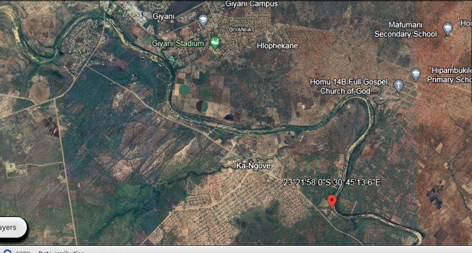
1-KleinLetabaEntry.JPG (115.84 KiB) Viewed 1065 times
Klein Letaba Rotstuin: 23°26'03"S 30°52'19"E
2.KleinLetabaRockGarden.JPG
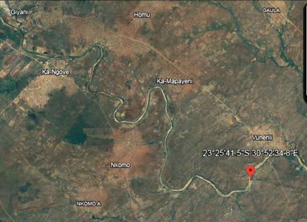
2.KleinLetabaRockGarden.JPG (59.85 KiB) Viewed 1065 times
Klein Letaba / KNP Fence: -23.491009, 31.059034
3-KleinLetabaKNP.Fence.JPG
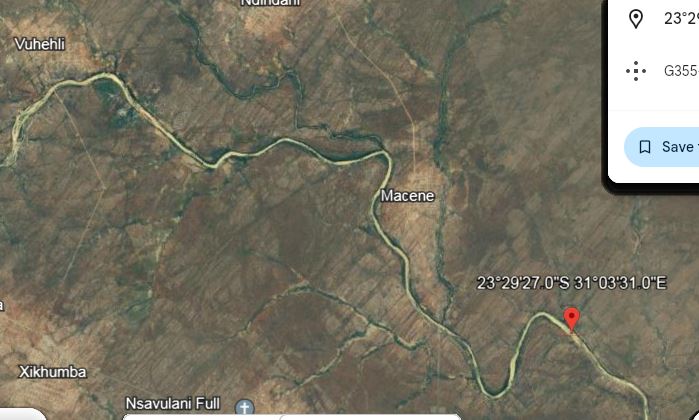
3-KleinLetabaKNP.Fence.JPG (58.52 KiB) Viewed 1065 times
Molototsi / Groot Letaba river crossing: -23.675369, 30.921053
4-MolototsiEntryPoint.JPG
Molotots Rowwe klip gedeelte: -23.569406, 30.747006
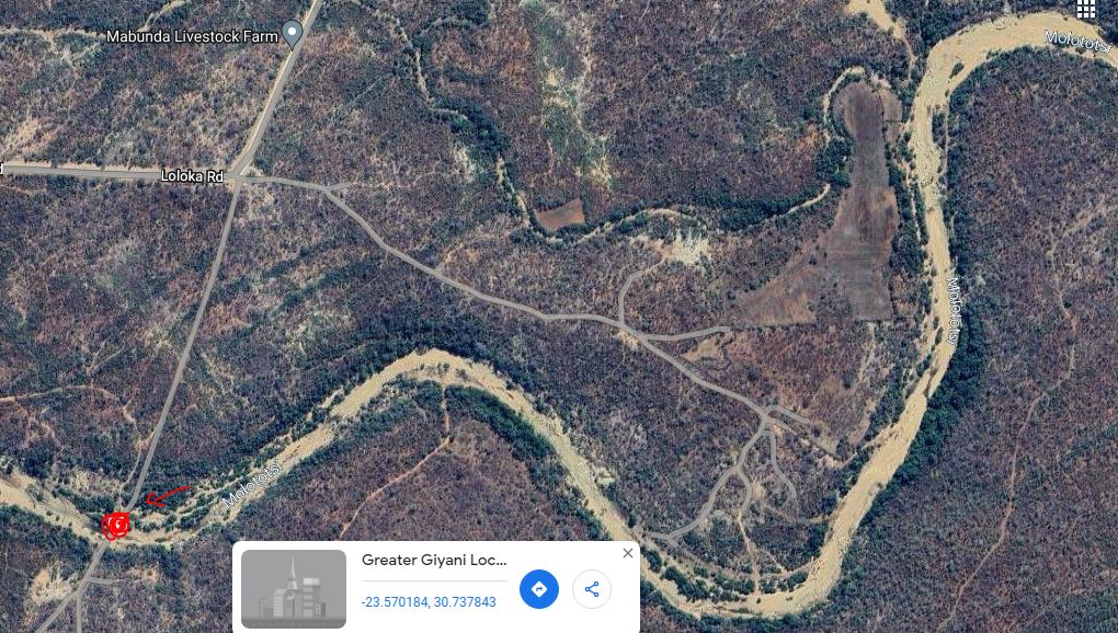
Start of Molototsi difficult terrain: 23°33'40"S 30°45'12"E
5-MolototsiRockyTerrain.JPG
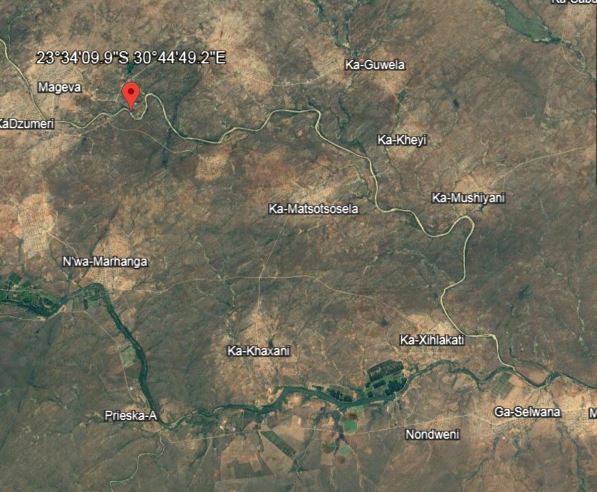
5-MolototsiRockyTerrain.JPG (68.72 KiB) Viewed 1065 times
5.1-MolototsiRockyTerrain.JPG
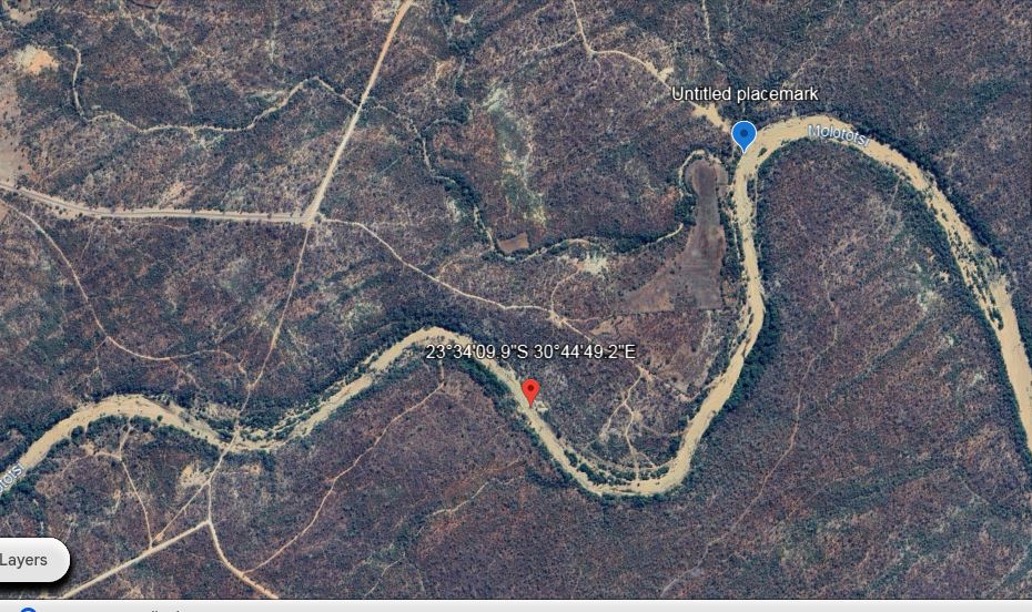
5.1-MolototsiRockyTerrain.JPG (167.54 KiB) Viewed 1065 times
re-entry after possible detour.JPG
re-entry after possible detour.JPG (208.7 KiB) Viewed 996 times
Dzumeri bridge. 23°34'19"S 30°42'39"E
dzumeri bridge.JPG

Molototsi Last year’s camp (2023) - 23°32'19"S 30°41'17"E
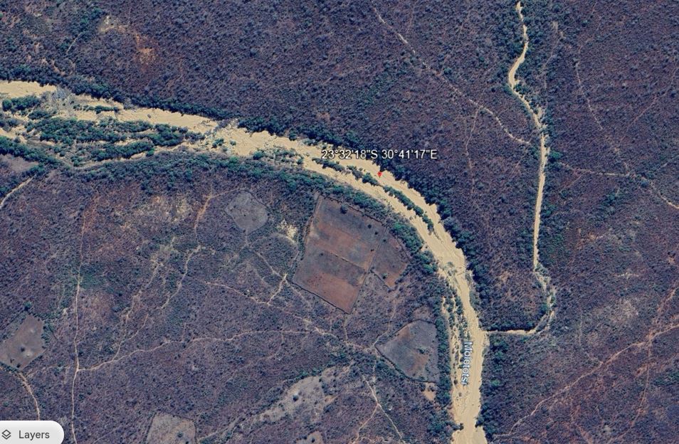
6-2023KampSpot.JPG
6-2023KampSpot.JPG (188.98 KiB) Viewed 1065 times
Molototsi Klip Bank (beautifull) 23°29'47"S 30°38'55"E
7-MolototsiKlipBank.JPG
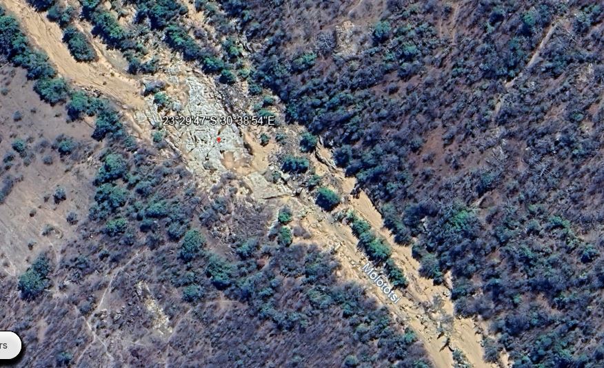
7-MolototsiKlipBank.JPG (158.31 KiB) Viewed 979 times
Good possible spot for last night camp:
8.GoodSpotForLastCamp.JPG
8.GoodSpotForLastCamp.JPG (135.85 KiB) Viewed 1065 times
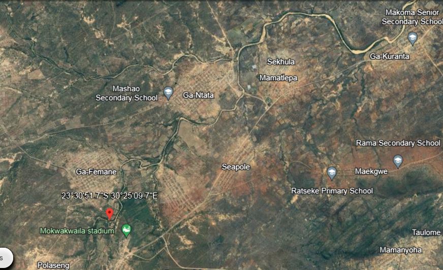
End of Molotots: -23.514360, 30.419357
9-MolototsiExitPoint.JPG
9-MolototsiExitPoint.JPG (114.74 KiB) Viewed 1065 times
Last edited by SJC on 18 May 2024 19:26, edited 2 times in total.
1996 Nissan Patrol 4.2 SGL
PsyPhin
Newbie
Newbie
Posts: 9
Joined: 26 Apr 2024 01:18
Full Name: Kevin
Nickname: PsyPhin
Home Town: Centurion
Current 4x4: GWM P series China Bakkie
Home Language: Eg
Has thanked: 12 times
Been thanked: 3 times

Re: River Trip 08-12 August 2024

Post by PsyPhin »

"Possible detour for low ground clearance vehicles...Exit point: 23°33'40"S 30°45'12"E
Re-entry by Dzumeri bridge. 23°34'19"S 30°42'39"E"

What do Patrol drivers consider as low clearance? I got around 250mm, but a long wheelbase and my breakover is quite shocking.
User avatar
SJC
Patrolman 1000+
Patrolman 1000+
Posts: 3328
Joined: 23 Nov 2014 14:20
Full Name: SJC
Nickname: Fanus
Home Town: Nelspruit
Current 4x4: 1996 Patrol 4.2 GQ (TB42)
Home Language: Afrikaans/English
Has thanked: 237 times
Been thanked: 203 times

Re: River Trip 08-12 August 2024

Post by SJC »

PsyPhin wrote: 16 May 2024 17:27 "Possible detour for low ground clearance vehicles...Exit point: 23°33'40"S 30°45'12"E
Re-entry by Dzumeri bridge. 23°34'19"S 30°42'39"E"

What do Patrol drivers consider as low clearance? I got around 250mm, but a long wheelbase and my breakover is quite shocking.
Ja, look maybe that came out wrong, not intended to pick on any vehicle here, Peet drive with his Fortuner everywhere and anywhere.
As long as you know your vehicle and which line to take, with the help of a good spotter there should not be a problem. (all of us need this at some spots regardless of vehicle brand).
That said...that section of the molototsi is getting sketchier each year, it is hard to predict what it would look like this year. With all the illegal sand mining taking place there is not enough sand to cover these rocks. Which were under sand couple of years ago.
Last year a few vehicles did look for detours as it was getting late and taking too long to navigate these huge rocks. Thats why I was looking into possibilities incase we need a detour. But we will have to play it by ear and see on the day what would be the best.
You can however bring with a piece of scaffolding plank, which can be used as a step. :mytwocents:
Attachments
molotots2.JPG
molotots1.jpeg
molotots1.jpeg (142.34 KiB) Viewed 1017 times
Last edited by SJC on 16 May 2024 20:41, edited 1 time in total.
1996 Nissan Patrol 4.2 SGL
PsyPhin
Newbie
Newbie
Posts: 9
Joined: 26 Apr 2024 01:18
Full Name: Kevin
Nickname: PsyPhin
Home Town: Centurion
Current 4x4: GWM P series China Bakkie
Home Language: Eg
Has thanked: 12 times
Been thanked: 3 times

Re: River Trip 08-12 August 2024

Post by PsyPhin »

SJC wrote: 16 May 2024 19:23
PsyPhin wrote: 16 May 2024 17:27 "Possible detour for low ground clearance vehicles...Exit point: 23°33'40"S 30°45'12"E
Re-entry by Dzumeri bridge. 23°34'19"S 30°42'39"E"

What do Patrol drivers consider as low clearance? I got around , but a long wheelbase and my breakover is quite shocking.
Ja, look maybe that came out wrong, not intended to pick on any vehicle here, Peet drive with his Fortuner everywhere and anywhere.
As long as you know your vehicle and which line to take, with the help of a good spotter there should not be a problem. (all of us need this at some spots regardless of vehicle brand).
That said...that section of the molototsi is getting sketchier eachy year, it is hard to predict what it would look like this year. With all the illegal sand mining taking place there is not enough sand to cover these rocks. Which were under sand couple of years ago.
Last year a few vehicles did look for detours as it was getting late and taking too long to navigate these huge rocks. Thats why I was looking into possibilities incase we need a detour. But we will have to play it by ear and see on the day what would be the best.
You can however bring with a piece of scaffolding plank, which can be used as a step. :mytwocents:
Wow looks rough. How long does the detour take?
I like a challenge but I can imagine I will be fatigued at this point and happy to skip some rough stuff.
Post Reply

Return to “29. Events”

Who is online

Users browsing this forum: Bing [Bot] and 4 guests