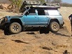

We had a great day exploring the Metsimotlhabe river about 50km west of Gaborone so I thought I would do a short trip report with maps and a few pictures in case anyone would like to do it one day. It's great fun with plenty of opportunities to test your vehicle or even just cruise along and enjoy the scenery.
The Metsimotlhabe is a large river that originates in the hills south west of Moshupa village and flows north east where it terminates in Bokaa dam just north east of Gaborone. The river is nearly 100 meters wide in places and flows through some spectacular hills and gorges. There are plenty of places that one could enter the river and so you can really just pick a spot on google earth and choose your own adventure. There was three vehicles in the convoy. My Mrs and I in the patrol with the dogs, my folks in their 2.8 Shorty and a hilux.
We chose to enter the river in the upper reaches just south of Moshupa town because one of us in the convoy had done this route before and we did not have to do any major planning, just pack the braai and beers and off we went.
Once you are in the river it's easy going with a firm base in most places but there are also plenty of areas where one could have a bit of fun testing the capabilities of your vehicle. We cruised down stream for about 4km before we found a nice shady place to have lunch. The whole drive in the river on the day was only about 10km but it feels like alot more when you are going slowly and constantly stopping to check places out. One could potentially drive the while length of the river but it would require more research and you would have to use your initiative to find routes around obsticals that might block your way. The whole length of the river is bordered by farm land and you will encounter locals along the way. Everyone is quite friendly and willing to show you the way around things or let you pass through their farms in exchange for a beer so stay friendly and polite and you will have a good time.
After lunch a storm formed upstream from us and we could see rain falling in the catchment so it was time to get out as none of our vehicles have outboards and pontoons. I have attached some of the pictures to give an idea of what it's like. I will try upload some videos onto the forum Facebook page also.
If anyone comes through Gabs and wants to do it give me a shout and I will give you more info. The river is constantly changing and my route may not be accessible in the future so you might have to do things differently. It's a great day trip either way.
Cheers